Authors: Heather McGinness, Kate Brandis, Veronica Doerr, Richard Kingsford, Ralph MacNally and John Martin
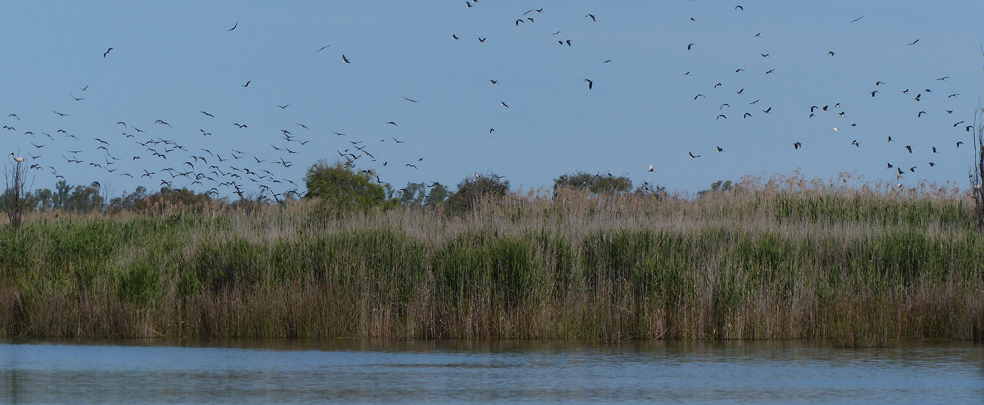
It’s a subject that has mystified many Australians and resulted in heated debates – how is it that large numbers of waterbirds are able to turn up in the most remote and unexpected places after years of absence, thousands of kilometres from where they are usually seen? How do they get there, where are they coming from and what are they responding to from so far away? Where do they go to feed and shelter in the time between their irregular breeding events? Why do they select some places and not others?
Answers to these questions are critical for land and water managers, as well as the curious public. With waterbird populations in decline across the Murray-Darling Basin and limited quantities of environmental water available to help address this decline, our efforts to improve and maintain waterbird habitats need to be guided by better knowledge of what waterbirds need, where and when. How can we be strategic with our limited resources to promote successful breeding, juvenile survival, and healthy populations in both the short-term and the long-term?
Figuring this out in Australia can be tricky because many of our species are highly nomadic, and others are decidedly ‘cryptic’ – meaning that they are hard to find and study. These characteristics mean that even basic life history or demographic data for common waterbird species can be hard to measure (e.g. population sizes and extents, juvenile survival rates, adult survival rates and longevity).
Technology is, however, catching up to some Australian birds. Through work done by the MDB EWKR Waterbird Theme we are starting to fill some of these knowledge gaps by tracking the movements of one waterbird species, the straw-necked ibis (acronym ‘SNI’), by using satellite GPS transmitters.
Colonially nesting waterbirds are primary focus for study in the MDB EWKR project because:
- They are one of the main waterbird indicators for environmental flows management and policy
- Response variables are more easily measured for these than for other species of waterbirds because breeding events and nests for these species are relatively easy to locate and to survey. Locations of major colonies are known, as are some of the breeding thresholds related to flows and inundation
- The effects of predation and other threats on these species are likely to be more easily measured because their nests, eggs and fledglings are relatively obvious
- There is good evidence that this group of waterbirds provides a good model for understanding relationships between environmental flows and waterbird recruitment.
The straw-necked ibis was chosen for satellite-tracking because they are good representatives of the above, are known to nest in large numbers in nearly all major MDB wetlands managed with environmental flows. The ibis is a species of particular interest to managers.
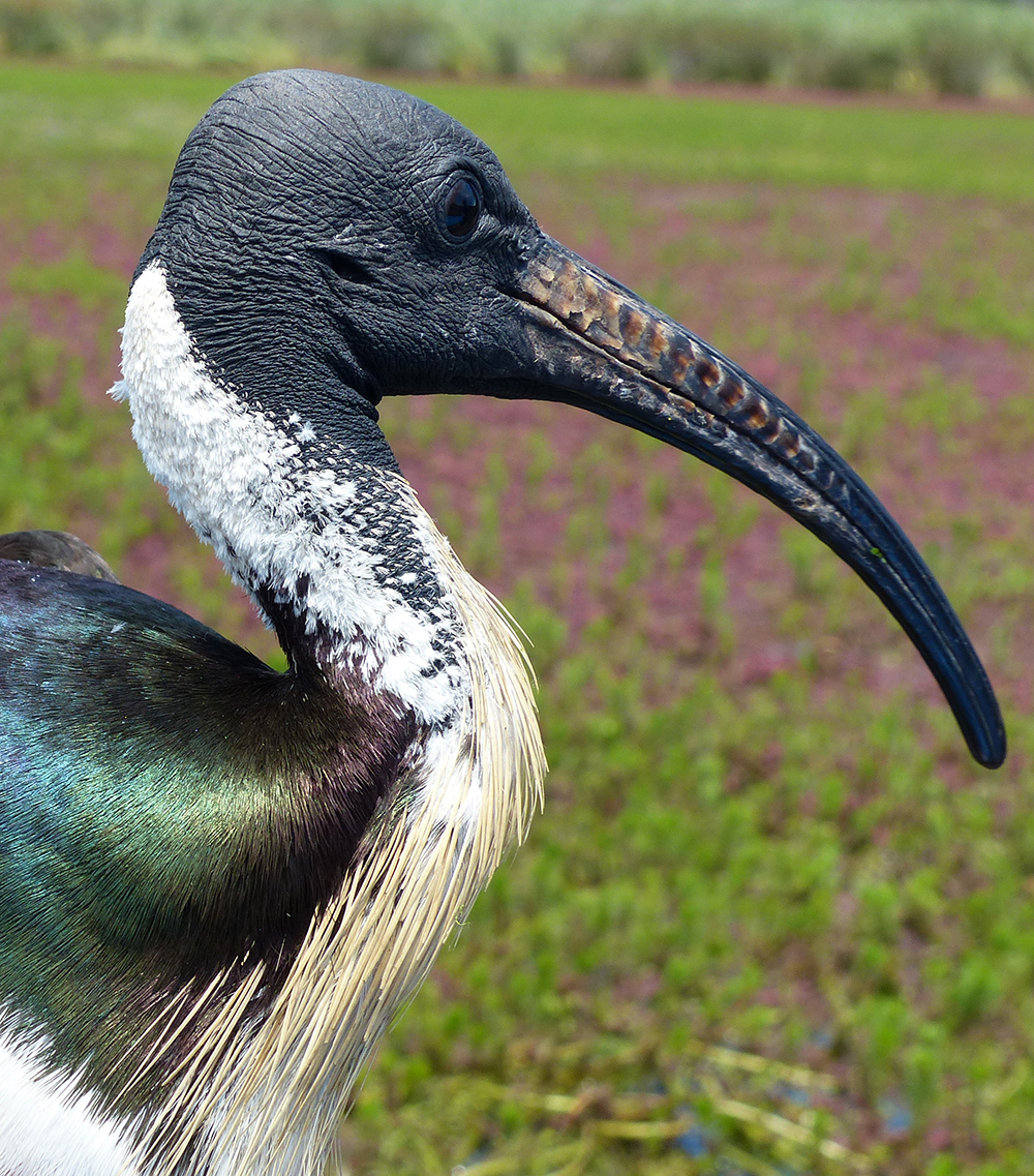
Straw-necked ibises have spectacular rainbow-hued iridescent dark feathers on their wings and back, and distinctive straw-like feathers on their necks. They are also known as the ‘farmer’s friend’ because when on dry land they eat large quantities of pest insects such as locusts. When in wetlands, they eat frogs, aquatic insects, spiders, fish, molluscs and small reptiles. They are generally thought to be less adaptable and opportunistic than the Australian white ibis (Threskiornis molucca), and don’t scavenge as much and tend to avoid saltwater areas. They are highly mobile and nomadic, and appear to have closer ties with inland floodplains and wetlands.
The transmitters record hourly GPS location fixes between 7 AM and 7 PM, as well as taking a midnight ‘fix’ to record roosting/nesting locations. The trackers have an accuracy of about 10 metres, are solar-charged and expected to transmit for at least two years.
During spring and summer 2016–2017, 20 ibises were fitted with transmitters. Five adults and ten juveniles were tracked from Barmah-Millewa forest in the southern MDB, and another five adults tracked from the Macquarie Marshes in the northern MDB. Another twenty or more SNI will tracked from 2017–2018.
Flying high
After just 9 months, the satellite tracking has already advanced our knowledge of previously poorly understood ibis movement and population patterns and trends.
Long-distance movements
Individual ibis have travelled long distances quickly. One adult female (‘Gracy’) was captured in the Macquarie Marshes in October 2016 after travelling over 400 km south to the Murrumbidgee River. In mid-November, she returned to the Macquarie River area before leaving in mid-January 2017 to travel north, reaching the Townsville area in early May, over 1200 km from the Marshes.
Northern and southern ibises are mixing and using some of the same sites and routes, consequently straw-necked ibises in the MDB may be one interacting population. We are cautious of asserting this however, as behaviour in the 2016–17 year may be unusual because of the extent and duration of flooding. This will need to be investigated with tracking in later years and with more birds.
Common ‘flyways’ or movement corridors for separate birds/groups
Six of the ten adults and three of the juveniles travelled along a particular NE–SW route within the MDB, in different directions. This route corresponds to zones or boundary lines in maps of average climatic conditions, rainfall, topography, etc. For examples of climate zones, see http://www.bom.gov.au/climate/averages/maps.shtml
Foraging and stopover points and regions
The Lachlan River floodplain near Condobolin was an important area for foraging by many of the tracked ibises in the 2016–17 summer. Tracking identified the re-use of other sites by different birds at different times in both Victoria and New South Wales. Identifying these areas could be important for future bird management. We found that birds are foraging in a range of land uses, including agricultural and native habitats.
‘Coupled’ habitats for roosting and foraging – adults
Foraging habitats seem to have remnant vegetation with large trees for roosting nearby. If these areas are preferred by the ibises, then the coupled habitats might be targeted for management.
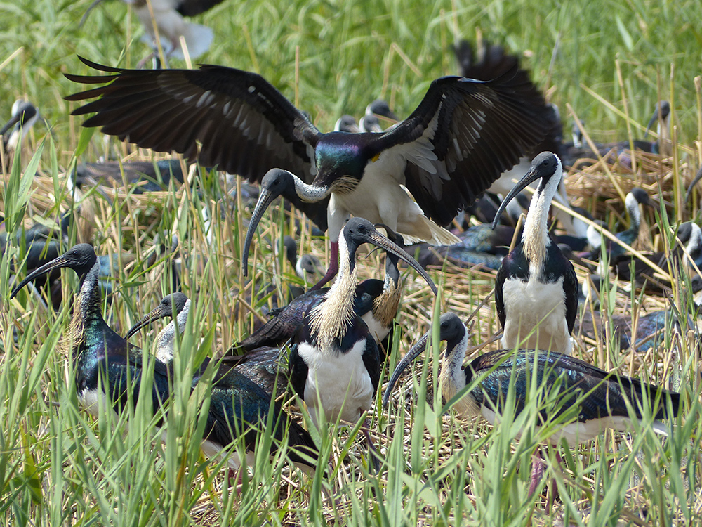
‘Coupled’ night vs day habitats – juveniles at nesting sites
Juveniles roost in one part of the nesting colony but spend the day ‘creching’ together in another part of the colony up to 100 metres away.
Variation in propensity to travel or remain as residents
Some birds have remained in one general area or catchment for months, while others have travelled nearly continuously, with some, such as ‘Gracy’ and ‘Byron’, moving more than 1000 km.
Movement associations with weather
Similarities in departure times and departure dates for long trips are probably associated with thermal upwellings, which is suggested by distances travelled per hour and by time of day. Weather changes may trigger long-distance movements, such as a drop in temperature with rainfall or a shift in wind direction.
High mortality rates – particularly for juveniles
Birds have died due to multiple causes, including botulism (a soil-borne bacterium), predation and vehicle impacts. The initial cause of mortality often cannot be definitively ascertained, with scavenging of carcasses (and transmitters!) very common by foxes and other mammals, and by birds. There are multiple possible causes of death in colonially nesting waterbirds and their young, including predation (e.g. raptors, foxes, cats and dogs), disease (e.g. botulism, which was widespread in 2016–17), parasites, poisoning, starvation, entanglement in nesting material and heat exhaustion. The extremely high temperatures recorded in the 2016-17 are likely to have had a negative impact on some birds. Juveniles are more susceptible than adults to these pressures, and so some losses from breeding events are not unexpected.
Data analyses to be conducted as part of the broader MDB EWKR project will explore these patterns and trends in more detail. Recommendations for land and water managers will be developed from the results, particularly focusing on the spatial and temporal locations, characteristics and requirements of foraging habitats and birds that may influence environmental watering, vegetation management or pest management decisions.
For more information:
- contact Waterbird Theme Coordinator, Heather McGinness: Heather.McGinness@csiro.au
- visit the CSIRO website, or our Facebook and Twitter page
Related links:
- More Wonderful Waterbird stories
- please visit the MDFRC website, Facebook Page or YouTube channel